
 Srpski
 English
- Digitalization of knowledge
- Human language technologies
- Bioinformatics
- Data mining
- Spatial data
- Mathematical modelling
Spatial data
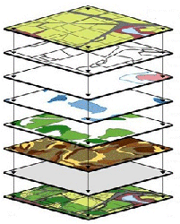
Spatial data are the data that have some spatial component, such as position in some coordinate system, which is usually attached to some other parameter. It can be, for example, latitude and longitude of a location from which a soil sample is taken, but it can also be a photo of a sample. For a computer, processing a photo involves processing spatial data too (photo dimension, contour recognition, colour recognition, relations between different aspects of a photo etc.). That is why we consider both cases as spatial data.
In the first case, when we need to process some locations on the Earth's surface, data are kept and managed with GIS systems. They are capable of analysing and visualizing data, and have a great number of applications in different scientific and economic fields. In agriculture, these systems are used for enhancing agricultural production by monitoring relevant parameters in the field, risk assessment, pest control, monitoring production, precise agriculture, management of water systems and alike.
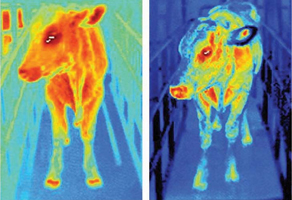
In the second case, very complex algorithms capable of automatic recognition of shapes, contours, patterns and colours are used for image processing. These algorithms and software based on them are used in different fields such as nano technologies, electronic microscopy, satellite pictures processing and others. In agriculture, image processing is used for weeds control, automatic selection of fruits and vegetables in production lanes, detection of diseases on plants and alike.